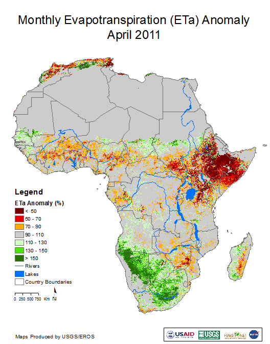
To meet the demands of food security early warning, the Famine Early Warning Systems Network (FEWS NET) has prioritized the development and implementation of alternate capabilities to monitor growing-season conditions using satellite imagery and models. A new FEWS NET remote sensing product provides estimates of actual evapotranspiration (ETa), which is directly proportional to crop yield. The estimate is based on the Operational Simplified Surface Energy Balance (SSEBop) model, recently described and accepted for publication by the Journal of American Water Resources Association (Senay et al., 2013). The ETa products are important because drought is the climate hazard that most threatens rural livelihood systems in countries that receive the great majority (between $1 and $2 billion) of annual food assistance provided by the U.S. Agency for International Development through the Office of Food for Peace. In these countries, it is difficult to characterize location, condition, and magnitude of emerging food production problems due to sparsely located and late-reporting climate stations and extension services.
The ETa product monitors actual vegetation water use in near-real time across rainfed and irrigated agriculture, natural vegetation, and wetlands. Using MODIS data (MODerate resolution Imaging Spectroradiometer), the product is currently operational to a 1-km resolution on 8-day, monthly, and seasonal time steps for Africa, central and southern Asia, and the conterminous United States.
Senay, G.B., Bohms, S., Singh, R.K., Gowda, P.H., Velpuri, N.M., Alemu, H., and Verdin, J.P., 2013, Operational evapotranspiration mapping using remote sensing and weather datasets—a new parameterization for the SSEB approach: Journal of the American Water Resources Association, v. 49, no. 3, p. 577-591. (Also available online at http://dx.doi.org/10.1111/jawr.12057.)
MODIS ETa anomaly image for Africa, April 2011. Red area in the Horn of Africa indicates drought associated with famine in Somalia and severe food insecurity in neighboring countries.


