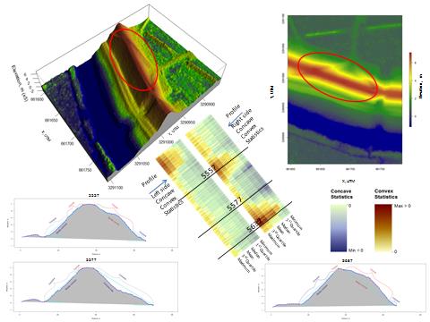
Flood protection in southern Louisiana is largely dependent on earthen levees, and following Hurricane Katrina no infrastructure has received more scrutiny than the State's levee system. The USGS is working with the Louisiana Coastal Protection and Restoration Authority, Louisiana Sea Grant, and local levee districts in Lafourche and Terrebonne Parish to map and monitor non-Federal levees using targeted airborne and terrestrial lidar surveys. Comprehensive, reliable elevation data are lacking for most levees in southern Louisiana because of high rates of subsidence and the difficulty of mapping long stretches of levees using a Global Positioning System or traditional surveying techniques. The purpose of the study is to demonstrate the ability to collect high-resolution, high-accuracy elevation data that will benefit local levee districts in southern Louisiana as well as the coastal monitoring and restoration community. In early 2012, high resolution lidar data were acquired following the centerline of each levee. A field survey was also conducted for selected levee segments using a mobile lidar scanner mounted on a truck to investigate improving the positional accuracy of the airborne lidar and to provide unique high-resolution side-view profiles of the selected sections. The USGS is developing a suite of analytical software tools to rapidly analyze lidar-derived levee metrics (see figure) including levee crest elevation, crown width, levee volume, etc. The lidar levee data will also be used to improve the USGS National Elevation Dataset (NED) for coastal Louisiana. Future levee lidar data acquisitions are planned to examine the feasibility of using lidar to monitor potential changes in levee elevation and volume with time.

An official website of the United States government
The .gov means it’s official.
Federal government websites often end in .gov or .mil. Before sharing sensitive
information, make sure you’re on a federal government site.
The site is secure.
The https:// ensures that you are connecting to the official website
and that any information you provide is encrypted and transmitted securely.

U.S. Department of the Interior
