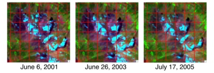
The spatial and temporal distribution of snow covered area (SCA) represents an important climate record for hydrologists, climatologists, ecologists, other scientists, and resource managers. Snow cover exhibits tremendous spatial and temporal variability and is commonly concentrated in remote or inaccessible regions, making spaceborne remote sensing the most feasible approach for comprehensive SCA monitoring. Presently, no single existing or planned instrument provides daily high spatial resolution imagery suitable for SCA mapping. Combining daily imagery from a moderate resolution sensor such as the Moderate Resolution Imaging Spectroradiometer (MODIS) with historical data from a higher spatial resolution sensor such as Landsat Thematic Mapper (TM) or Landsat Enhanced Thematic Mapper Plus (ETM+) allows the construction of daily high spatial resolution SCA time series data (see figure showing SCA). The feasibility of this approach has been demonstrated in the Sierra Nevada of California and will soon be expanded to cover the entire western United States.
The snow covered area (SCA) downscaling technique capitalizes on the consistency of SCA patterns across years despite wide variability in snowmelt timing. The red squares represent 500-meter MODIS pixels overlain on Landsat imagery.


